Why do they call it College Station?
The Houston and Texas Central Railway built through the area in 1860. In 1871 the site was chosen as the location of the proposed Texas A&M College, which opened in 1876. In 1877 a post office, College Station, was opened in a building near the railroad tracks, and the community took its name from the post office. A railroad depot was constructed in 1883; By 1884 the community had 350 inhabitants and two general stores. Faculty members generally lived on campus in housing provided by the university. College Station received electrical service in the 1890s; the population was 391 in 1900.

.
.
.
.
.
.
.
.
.
.
.
.
.
.
.
College Station 1883
.
.
Do the Arbuckle mountains, Wichita mountains and the Amarillo Uplift (aka Amarillo mountains) have anything in common?
Yes, they are all part of a mountain range that runs east/west. The Wichita-Amarillo and Arbuckle mountains are the furthest east part of the Ancestral Rocky Mountains. The Wichita Mountains of southwestern Oklahoma, and part of the Arbuckle Mountains of southern Oklahoma, are the surface expression of the Cambrian Southern Oklahoma Aulacogen. The Amarillo Mountains lay buried 1,500 feet beneath the high plains.
The Arbuckle Mountains are an ancient mountain range in south-central Oklahoma in the United States. The Arbuckle’s date back to 540-440 million years ago in the latest Precambrian and earliest Paleozoic era, and reach a height of 1,412 feet above sea level. Click to read more.
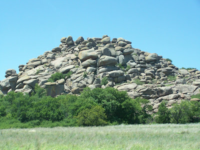
Pictures of the Wichita Mountains (click on the pic's for a larger view).


The Wichita Mountains are located in southwestern Oklahoma. The Wichita Mountains Wildlife Refuge, a favorite for hikers and rock climbers in the region, is located adjacent to Cache, Oklahoma, Medicine Park, Oklahoma, and historic Meers, Oklahoma while just a short drive from Lawton, Oklahoma. The Field Artillery capital of the world, Fort Sill, occupies the southern part of the range. Click to read more.

Amarillo Mountains -- -- Folks here on the High Plains are being deprived of their view of the mile-high mountains that stretch across the central Panhandle.
But the Amarillo Mountains are buried deep . . . deep below the Rocky Mountain sweepin's that were brushed into our corner roughly 100- to 200 million years ago, say geophysicists and explorers who have spent years studying the Panhandle's hidden treasures. We would have to dig 2,500 feet just to see the mountain range's tallest peak, in northeast Potter County under the Alibates National Monument.
The submerged granite mountains, lined by shallow faults and vast basins of oil and gas, would be part of the Wichita Mountain range in Lawton, Okla.
About 300 million years ago, the Wichita and Amarillo mountains were forced up out of the earth by a fault that begins in Dallas and stretches into northern New Mexico. The Appalachian Mountains were formed about the same time. Click to read more.
Was the Spindletop oil well in the East Texas oil field at Kilgore Texas?
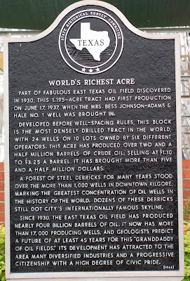
No, Spindletop was drilled at Beaumont but the oil field known as the richest acre in the world is at Kilgore.
Kilgore Texas
Home to the world’s richest acre. 24 wells on 1.195 acres of land produced 2,500,000 barrels of oil.


.
.
.
.
.
.
.
.
.
.
.
.
.
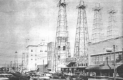
In the 1940s, a drive through Kilgore was unlike any other excursion into East Texas. More than 1,000 wooden oil derricks -- perhaps the most visible evidence of the East Texas oil boom -- lined the town’s streets. During the Christmas season, lights were hung on many of the derricks. And one plot of ground was known as “the world’s richest acre.” Click to read more.

.(click on the pic for a larger view)
.
.
.
.
.
.
.
.
.
.
.
.
.
.
.
.
.
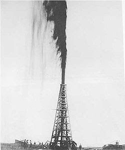
Spindletop~ Beaumont Texas
There had long been suspicions that oil might be under "Spindletop Hill." The area was known for its sulfur springs and bubbling gas seepages that would ignite if lit. In August 1892, George W. O'Brien, George W. Carroll, Pattillo Higgins and others formed the Gladys City Oil, Gas, and Manufacturing Company to do exploratory drilling on Spindletop Hill. The company drilled many dry holes and ran into trouble, as investors began to balk at pouring more money into drilling with no oil to show for it. Click to read more.

.
.
.
.
.
.
.
.
.
.
.
.
.
.
This week’s top pick “best place to eat” is Dieter Brothers in Lindsey Texas. Great Bar-B-Q!


.
.
.
.
.
.
.
.
.
.
.
.
.
.
.
.
.
.
.
.
Dieter Bros. purchased the old Metzler Bros. Drive Inn in 1997. The original Metzler Bros. was established in 1947 in Oklahoma, and later relocated in Lindsay, TX in 1960. The business was operated by the Metzler family until its sale to the Dieters in 1997. After a period of remodel, the Dieter Bros, Pat and John re-opened the restaurant for business. Dieter Bros Restaurant is located 4 miles West of Gainesville, TX on U.S. Hwy. 82 in the small town of Lindsay TX. Click to read more.


